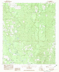
1982 Map of Neely
USGS Topo · Published 1982About this map
The Leaf River winds along the western border of this Greene County landscape, defining a terrain of numerous creek branches and bottomlands. Within the De Soto National Forest, the map records rural landmarks and small settlements connected by a winding network of roads and the Illinois Central Gulf railroad. Local genealogy is well-represented through family-named features like Sylvester Cem and several community houses of worship, including Pleasant Hill Ch and Buffalo Ch.
Find a feature on this map
46 named features on this map. Tap any name to fly to it.
Don’t see what you’re looking for? This feature index may not catch every label — zoom into the map to look around manually.
Map Details
Editions of this 1982 Neely Map
This is the sole edition of this map. No revisions or reprints were ever made.
Other maps of this area

1947 · Beaumont
USGS Topo · 1:62,500

1949 · Beaumont
USGS Topo · 1:62,500

1953 · Hattiesburg
USGS Topo · 1:250,000

1958 · Hattiesburg
USGS Topo · 1:250,000

1963 · Brewer
USGS Topo · 1:24,000

1964 · Richton
USGS Topo · 1:24,000

1964 · Avera
USGS Topo · 1:24,000

1973 · Jonathan
USGS Topo · 1:24,000
1973 · Leakesville SW
USGS Topo · 1:24,000
1982 · Beaumont
USGS Topo · 1:24,000