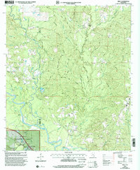
2000 Map of Neely
USGS Topo · Published 2002About this map
The Leaf River basin dominates this portion of the De Soto National Forest, where the river winds past Red Bluff and Mossy Hammock. Near the Greene and Perry County line, the landscape is defined by a dense network of creek drainages including Atkinson Creek, Gaines Creek, and McSwain Creek. The settlement of Neely sits in the southeast corner, serving as a focal point for the surrounding rural area. This 2000 revision reveals a community structured around its spiritual and social centers, with numerous country churches such as Buffalo Ch, Pleasant Hill Ch, and Faithope Ch scattered across the uplands. Significant land features like the Hillman Hills and the Gee Dee Hills illustrate the varying elevations of the piney woods, while industrial markers like the Substation Pumping Station and several pipelines trace the modern infrastructure cutting through the timberlands.
Find a feature on this map
57 named features on this map. Tap any name to fly to it.
Don’t see what you’re looking for? This feature index may not catch every label — zoom into the map to look around manually.
Map Details
Editions of this 2000 Neely Map
This is the sole edition of this map. No revisions or reprints were ever made.
Other maps of this area

1947 · Beaumont
USGS Topo · 1:62,500

1949 · Beaumont
USGS Topo · 1:62,500

1953 · Hattiesburg
USGS Topo · 1:250,000

1958 · Hattiesburg
USGS Topo · 1:250,000

1963 · Brewer
USGS Topo · 1:24,000

1964 · Richton
USGS Topo · 1:24,000

1964 · Avera
USGS Topo · 1:24,000

1973 · Jonathan
USGS Topo · 1:24,000
1973 · Leakesville SW
USGS Topo · 1:24,000
1982 · Neely
USGS Topo · 1:24,000