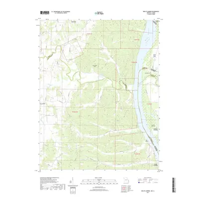
2017 Map of Neelys Landing
USGS Topo · Published 2017About this map
The Mississippi River corridor defines the eastern edge of this Missouri and Illinois borderland, where the Big Muddy River reaches its confluence. In Missouri, the historic settlement of Altenburg and the rural community of New Wells anchor the higher ground west of the Birmingham Hills. The river geography is characterized by significant features such as Grand Tower Island, Big Muddy Island, and Crawford Towhead, which demonstrate the shifting nature of the channel and its mid-stream landmasses. Along the banks, historic river access points like Neelys Landing and Bennett Landing highlight the region's long-standing connection to water-based transit. The interior is dissected by numerous drainages, including Apple Creek, Shawnee Cr, and Lovejoy Cr, which have shaped the local topography of hollows and ridges.
Find a feature on this map
58 named features on this map. Tap any name to fly to it.
Don’t see what you’re looking for? This feature index may not catch every label — zoom into the map to look around manually.
Map Details
Editions of this 2017 Neelys Landing Map
This is the sole edition of this map. No revisions or reprints were ever made.
Other maps of this area

1918 · Altenburg
USGS Topo · 1:62,500

1920 · Jonesboro
USGS Topo · 1:62,500

1922 · Cape Girardeau
USGS Topo · 1:62,500

1923 · Jonesboro
USGS Topo · 1:62,500

1924 · Cape Girardeau
USGS Topo · 1:62,500

1924 · Alto Pass
USGS Topo · 1:62,500

1925 · Altenburg
USGS Topo · 1:62,500

1947 · Jonesboro
USGS Topo · 1:62,500

1947 · Alto Pass
USGS Topo · 1:62,500

1947 · Crosstown
USGS Topo · 1:24,000