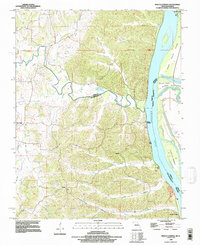
1993 Map of Neelys Landing
USGS Topo · Published 1996About this map
Apple Creek meanders through the dissected uplands of northern Cape Girardeau County before emptying into the Mississippi River, defining the county line with Perry County. This 1990s revision of earlier data captures a rural riverfront landscape where small settlements like New Wells and Lovejoy sit back from the bluffs, while Neelys Landing and Hines Landing mark historic points of contact with the river traffic. Across the water, the confluence of the Big Muddy River and the main channel creates a complex of islands and chutes, including Big Muddy Island and the prominent Grand Tower formation.
Find a feature on this map
22 named features on this map. Tap any name to fly to it.
Don’t see what you’re looking for? This feature index may not catch every label — zoom into the map to look around manually.
Map Details
Editions of this 1993 Neelys Landing Map
This is the sole edition of this map. No revisions or reprints were ever made.
Other maps of this area

1918 · Altenburg
USGS Topo · 1:62,500

1920 · Jonesboro
USGS Topo · 1:62,500

1922 · Cape Girardeau
USGS Topo · 1:62,500

1923 · Jonesboro
USGS Topo · 1:62,500

1924 · Cape Girardeau
USGS Topo · 1:62,500

1924 · Alto Pass
USGS Topo · 1:62,500

1925 · Altenburg
USGS Topo · 1:62,500

1947 · Jonesboro
USGS Topo · 1:62,500

1947 · Alto Pass
USGS Topo · 1:62,500

1947 · Crosstown
USGS Topo · 1:24,000