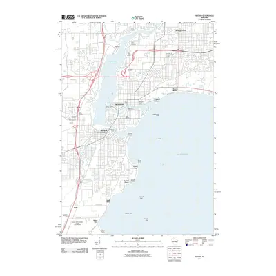
2010 Map of Neenah
USGS Topo · Published 2010About this map
The Fox River system and the expansive waters of Lake Winnebago dominate this landscape, defining the industrial and residential development of Neenah, Menasha, and southern Appleton. The twin cities are physically linked by Doty Island, situated between the Menasha Channel and the main river course. This area serves as a significant hydraulic hub, anchored by the Menasha Genlaws Dam and Neenah Dam, reflecting the region's long-standing reliance on water power and navigation.
Find a feature on this map
63 named features on this map. Tap any name to fly to it.
Don’t see what you’re looking for? This feature index may not catch every label — zoom into the map to look around manually.
Map Details
Editions of this 2010 Neenah Map
This is the sole edition of this map. No revisions or reprints were ever made.
Other maps of this area

1911 · Neenah
USGS Topo · 1:62,500

1955 · Neenah
USGS Topo · 1:62,500

1955 · Appleton
USGS Topo · 1:24,000

1955 · Appleton
USGS Topo · 1:62,500

1955 · Neenah
USGS Topo · 1:24,000

1955 · Green Bay
USGS Topo · 1:250,000

1956 · New London
USGS Topo · 1:48,000

1961 · Oshkosh
USGS Topo · 1:24,000

1961 · Oshkosh
USGS Topo · 1:62,500

1961 · Oshkosh NE
USGS Topo · 1:24,000