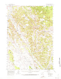
1957 Map of Nefsy Divide
USGS Topo · Published 1973About this map
The Nefsy Divide forms a significant topographic spine through this portion of Crook County, separating the drainages of the Belle Fourche River and Inyan Kara Creek. This mid-century landscape is defined by the ranching and early petroleum operations of the Black Hills National Forest region. The settlement pattern is dominated by established homesteads and rural infrastructure, including the Zimmerman Ranch, Old HK Ranch, and the small community at Linden.
Find a feature on this map
56 named features on this map. Tap any name to fly to it.
Don’t see what you’re looking for? This feature index may not catch every label — zoom into the map to look around manually.
Map Details
Editions of this 1957 Nefsy Divide Map
3 editions found

Other maps of this area

1898 · Sundance
USGS Topo · 1:125,000

1901 · Aladdin
USGS Topo · 1:125,000

1902 · Sundance
USGS Topo · 1:125,000

1903 · Aladdin
USGS Topo · 1:125,000

1905 · Devils Tower
USGS Topo · 1:125,000

1918 · Moorcroft
USGS Topo · 1:125,000

1918 · Moorcroft
USGS Topo · 1:62,500

1954 · Sunny Divide
USGS Topo · 1:24,000

1954 · Carlile
USGS Topo · 1:24,000

1954 · Missouri Buttes
USGS Topo · 1:24,000