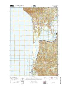
2014 Map of Nehalem
USGS Topo · Published 2014About this map
Neahkahnie Mtn stands as a prominent coastal landmark where the Oregon shoreline meets the Pacific Ocean, anchoring a landscape defined by the intricate mouth of the Nehalem River. This 2014 survey reveals a dense succession of seaside communities and beaches, from Neahkahnie Beach and Manzanita in the north down to Manhattan Beach and Rockaway Beach at the southern edge. The central Nehalem Bay is protected by the long Nehalem Spit, which also contains the Nehalem Bay State Airport.
Find a feature on this map
110 named features on this map. Tap any name to fly to it.
Don’t see what you’re looking for? This feature index may not catch every label — zoom into the map to look around manually.
Map Details
Editions of this 2014 Nehalem Map
This is the sole edition of this map. No revisions or reprints were ever made.
Other maps of this area

1937 · Nehalem
USGS Topo · 1:62,500

1940 · Cape Falcon
USGS Topo · 1:62,500

1943 · Nehalem
USGS Topo · 1:62,500

1948 · Vancouver
USGS Topo · 1:250,000

1950 · Vancouver
USGS Topo · 1:250,000

1950 · Vancouver
USGS Topo · 1:250,000

1955 · Nehalem
USGS Topo · 1:62,500
1955 · Cannon Beach
USGS Topo · 1:62,500

1958 · Vancouver
USGS Topo · 1:250,000

1964 · Vancouver
USGS Topo · 1:250,000