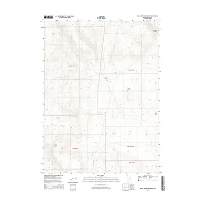
2015 Map of Nellie Spring Mountain
USGS Topo · Published 2015About this map
Nellie Spring Mtn anchors this arid Great Basin landscape in Washoe County, where ephemeral water sources and distinct geological formations define the territory. The topography is dominated by the Massacre Range in the northwest and the deep cut of High Rock Canyon to the northeast. Navigation through this remote terrain follows the High Rock Canyon Rd, which traces the low ground near High Rock Cr. The map reveals a network of vital water points necessary for survival in the high desert, including Indian Spring, Lower Indian Spring, and Fern Spring. Man-made intervention is visible at the Argo Reservoir, while natural landmarks like Grassy Rock, Grassy Wash, and Grassy Canyon provide essential orientation in a region of shifting desert drainages.
Find a feature on this map
17 named features on this map. Tap any name to fly to it.
Don’t see what you’re looking for? This feature index may not catch every label — zoom into the map to look around manually.
Map Details
Editions of this 2015 Nellie Spring Mountain Map
This is the sole edition of this map. No revisions or reprints were ever made.
Other maps of this area

1889 · Long Valley
USGS Topo · 1:250,000

1954 · Vya
USGS Topo · 1:250,000

1958 · Vya
USGS Topo · 1:250,000

1962 · Vya
USGS Topo · 1:250,000

1966 · Nut Mountain
USGS Topo · 1:24,000

1966 · Massacre Creek
USGS Topo · 1:24,000

1966 · Painted Point
USGS Topo · 1:24,000

1972 · Mahogany Mtn
USGS Topo · 1:24,000
1972 · Yellow Hills West
USGS Topo · 1:24,000

1978 · Hart Mountain
USGS Topo · 1:24,000