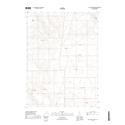
2018 Map of Nellie Spring Mountain
USGS Topo · Published 2018About this map
Nellie Spring Mtn rises above a desert landscape defined by essential water sources and the dramatic geology of Northwest Nevada. This 2018 survey documents a region where life and travel center on the availability of water, marked by sites like Argon Reservoir, Lower Indian Spring, and Fern Spring. The terrain transitions from the high elevations of the Massacre Range in the northwest toward the deep incision of High Rock Canyon in the northeast. Transportation is limited to the winding path of High Rock Canyon Rd, which traces the natural corridors of the high desert. Notable landmarks such as Grassy Rock and the wide drainage of Grassy Wash suggest the sparse, seasonal vegetation patterns of this arid environment, while the presence of multiple named springs emphasizes their critical importance to the area's geography.
Find a feature on this map
17 named features on this map. Tap any name to fly to it.
Don’t see what you’re looking for? This feature index may not catch every label — zoom into the map to look around manually.
Map Details
Editions of this 2018 Nellie Spring Mountain Map
This is the sole edition of this map. No revisions or reprints were ever made.
Other maps of this area

1889 · Long Valley
USGS Topo · 1:250,000

1954 · Vya
USGS Topo · 1:250,000

1958 · Vya
USGS Topo · 1:250,000

1962 · Vya
USGS Topo · 1:250,000

1966 · Nut Mountain
USGS Topo · 1:24,000

1966 · Massacre Creek
USGS Topo · 1:24,000

1966 · Painted Point
USGS Topo · 1:24,000

1972 · Mahogany Mtn
USGS Topo · 1:24,000
1972 · Yellow Hills West
USGS Topo · 1:24,000

1978 · Hart Mountain
USGS Topo · 1:24,000