
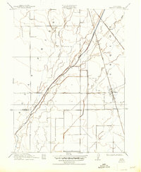
1912 Map of Nelson
USGS Topo · Published 1912About this map
The Nelson and Esquon settlements serve as the primary anchors for this 1910 survey of the California Central Valley. Dominated by a highly organized grid of irrigation and land divisions, the landscape is defined by the critical infrastructure of the Southern Pacific RR (Marysville Line) and the Northern Electric RR, which parallel the natural drainage of Butte Creek. The map documents the intricate water management of the era, from the winding path of Durham Slough to the seasonal courses of Ash Creek and Roberts Creek.
Find a feature on this map
10 named features on this map. Tap any name to fly to it.
Don’t see what you’re looking for? This feature index may not catch every label — zoom into the map to look around manually.
Map Details
Editions of this 1912 Nelson Map
2 editions found
Other maps of this area

1888 · Marysville
USGS Topo · 1:125,000

1891 · Chico
USGS Topo · 1:125,000

1891 · Marysville
USGS Topo · 1:125,000

1893 · Chico
USGS Topo · 1:125,000

1894 · Marysville
USGS Topo · 1:125,000

1895 · Marysville
USGS Topo · 1:125,000

1895 · Chico
USGS Topo · 1:125,000

1911 · Landlow
USGS Topo · 1:31,680

1912 · Dry Creek
USGS Topo · 1:31,680

1912 · Durham
USGS Topo · 1:31,680