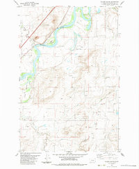
1983 Map of Nelson Island
USGS Topo · Published 1983About this map
Missouri River currents dominate this 1983 survey of Cascade County, where the waterway creates a significant physical boundary near Nelson Island. The landscape is defined by the convergence of numerous named drainages, including Muddy Creek, Little Muddy Creek, and Chestnut Valley Creek, illustrating the complex hydrology of the Montana plains. The Burlington Northern railroad follows the river's path, tracing the vital transportation corridor that linked these rural ranching and farming lands to broader markets.
Find a feature on this map
13 named features on this map. Tap any name to fly to it.
Don’t see what you’re looking for? This feature index may not catch every label — zoom into the map to look around manually.
Map Details
Editions of this 1983 Nelson Island Map
This is the sole edition of this map. No revisions or reprints were ever made.
Other maps of this area

1886 · Great Falls
USGS Topo · 1:250,000

1949 · Cascade
USGS Topo · 1:62,500

1951 · Cascade
USGS Topo · 1:62,500

1954 · Great Falls
USGS Topo · 1:250,000

1955 · Gore Hill
USGS Topo · 1:62,500

1957 · Great Falls
USGS Topo · 1:250,000

1961 · Rocky Reef
USGS Topo · 1:24,000

1961 · Schrammeck Lake
USGS Topo · 1:24,000
1965 · Antelope Butte
USGS Topo · 1:24,000
1965 · Truly
USGS Topo · 1:24,000