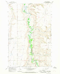
1965 Map of Truly
USGS Topo · Published 1968About this map
The Smith River carves a deep, winding path through this portion of Cascade County, separating the high agricultural plateaus of Truly Bench and Swede Bench. In the mid-1960s, this landscape was defined by its scattered rural settlements and the vital water sources that sustained them, including Castner Falls and several named coulees like Goodman Coulee and Ming Coulee.
Find a feature on this map
21 named features on this map. Tap any name to fly to it.
Don’t see what you’re looking for? This feature index may not catch every label — zoom into the map to look around manually.
Map Details
Editions of this 1965 Truly Map
This is the sole edition of this map. No revisions or reprints were ever made.
Other maps of this area

1886 · Great Falls
USGS Topo · 1:250,000

1949 · Cascade
USGS Topo · 1:62,500

1951 · Cascade
USGS Topo · 1:62,500

1954 · Great Falls
USGS Topo · 1:250,000

1955 · Gore Hill
USGS Topo · 1:62,500

1957 · Great Falls
USGS Topo · 1:250,000

1961 · Schrammeck Lake
USGS Topo · 1:24,000

1965 · Eden
USGS Topo · 1:24,000
1965 · Antelope Butte
USGS Topo · 1:24,000
1965 · Southwest Great Falls
USGS Topo · 1:24,000