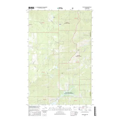
2017 Map of Nelson Peak
USGS Topo · Published 2017About this map
The Little Pend Oreille National Wildlife Refuge anchors the southern portion of this landscape, where the waters of Deer Lake and the Middle Fork Calispell Creek drain a high-relief terrain along the Stevens and Pend Oreille County line. This modern survey illustrates the vast overlapping administrative boundaries of the Colville National Forest and Kaniksu National Forest, showing a network of forest service roads including Natl Forest Develop Road 487 Rd and the Cottonwood Divide Rd that provide access to the high points of Nelson Peak and Benson Peak. The presence of numerous small water bodies such as Nelson Lake, Benson Lake, and Buzzard Lake, alongside distinct high-elevation openings like Betts Meadows, suggests a region managed for timber, wildlife habitat, and watershed protection. This 2017 edition provides the exact placement of local roads and property divisions within the Township and Range system.
Find a feature on this map
41 named features on this map. Tap any name to fly to it.
Don’t see what you’re looking for? This feature index may not catch every label — zoom into the map to look around manually.
Map Details
Editions of this 2017 Nelson Peak Map
This is the sole edition of this map. No revisions or reprints were ever made.
Other maps of this area

1927 · Chewelah
USGS Topo · 1:125,000

1930 · Chewelah
USGS Topo · 1:125,000

1936 · Newport
USGS Topo · 1:96,000

1942 · Newport
USGS Topo · 1:125,000

1958 · Sandpoint
USGS Topo · 1:250,000

1963 · Sandpoint
USGS Topo · 1:250,000

1964 · Chewelah
USGS Topo · 1:24,000

1964 · Goddards Peak
USGS Topo · 1:24,000

1964 · Chewelah Mtn
USGS Topo · 1:62,500
1965 · Valley
USGS Topo · 1:24,000