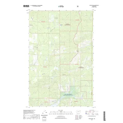
2020 Map of Nelson Peak
USGS Topo · Published 2020About this map
Nelson Peak and Benson Peak dominate this section of the Selkirk Mountains, where several national protected areas converge along the Stevens Co Pend Oreille Co border. The landscape is defined by its dramatic relief and numerous high-elevation water bodies, including Buzzard Lake and the smaller Benson Lake. High meadows such as Betts Meadows and Woodward Meadows appear among the timbered ridges, indicating natural clearings in the Colville National Forest and Kaniksu National Forest. In the southern portion of the map, the terrain descends toward the shores of Deer Lake, where a network of local roads like N Deer Lake Rd and Paradise View Landing Rd marks the transition from wilderness to lakeside settlement. The inclusion of the Little Pend Oreille National Wildlife Refuge underscores the region's importance for habitat conservation amidst the active forestry lands.
Find a feature on this map
31 named features on this map. Tap any name to fly to it.
Don’t see what you’re looking for? This feature index may not catch every label — zoom into the map to look around manually.
Map Details
Editions of this 2020 Nelson Peak Map
This is the sole edition of this map. No revisions or reprints were ever made.
Other maps of this area

1927 · Chewelah
USGS Topo · 1:125,000

1930 · Chewelah
USGS Topo · 1:125,000

1936 · Newport
USGS Topo · 1:96,000

1942 · Newport
USGS Topo · 1:125,000

1958 · Sandpoint
USGS Topo · 1:250,000

1963 · Sandpoint
USGS Topo · 1:250,000

1964 · Chewelah
USGS Topo · 1:24,000

1964 · Goddards Peak
USGS Topo · 1:24,000

1964 · Chewelah Mtn
USGS Topo · 1:62,500
1965 · Valley
USGS Topo · 1:24,000