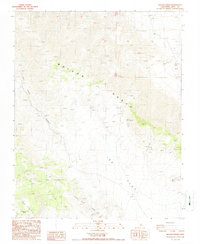
1987 Map of Nelson Range
USGS Topo · Published 1987About this map
Nelson Range dominates this 1980s topographic study, where the high desert terrain of Inyo County meets the eastern edges of the Inyo Mountains. This arid landscape is defined by its deep drainages and isolated resource extraction points, including several unnamed prospects and a Borrow Pit near the northern boundary. The presence of ruins in the southwestern corner, situated near the head of San Lucas Canyon, provides a rare indication of former human habitation or seasonal activity in this demanding environment.
Find a feature on this map
14 named features on this map. Tap any name to fly to it.
Don’t see what you’re looking for? This feature index may not catch every label — zoom into the map to look around manually.
Map Details
Editions of this 1987 Nelson Range Map
This is the sole edition of this map. No revisions or reprints were ever made.
Other maps of this area

1908 · Ballarat
USGS Topo · 1:250,000

1913 · Ballarat
USGS Topo · 1:250,000

1948 · Death Valley
USGS Topo · 1:250,000

1950 · Darwin
USGS Topo · 1:62,500

1950 · New York Butte
USGS Topo · 1:62,500

1950 · Ubehebe Peak
USGS Topo · 1:62,500

1951 · New York Butte
USGS Topo · 1:62,500

1951 · Darwin
USGS Topo · 1:62,500

1951 · Ubehebe Peak
USGS Topo · 1:62,500

1951 · Keeler
USGS Topo · 1:62,500