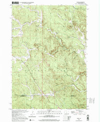
1998 Map of Nemo
USGS Topo · Published 2001About this map
Black Hills National Forest land dominates this high-altitude landscape, where the 1998 terrain reflects a century of mining and rural settlement near the boundary of Lawrence and Pennington counties. The small community of Nemo is positioned near Richard Draw, while historical industry is noted at the Lucky Strike Mine to the northwest. High points like Crystal Mountain and Pilot Knob overlook a complex network of drainages, including Boxelder Creek and Jim Creek. Local civic life is anchored by the Hillside Sch, and smaller named locales such as Merritt, Novak, and Greenwood appear alongside family-named landmarks like White Mansion. The map provides a detailed view of the drainage patterns through numerous draws such as Wilson Draw and Green Draw, illustrating how the mountainous topography shaped road and ranch placement in this portion of the Black Hills.
Find a feature on this map
33 named features on this map. Tap any name to fly to it.
Don’t see what you’re looking for? This feature index may not catch every label — zoom into the map to look around manually.
Map Details
Editions of this 1998 Nemo Map
This is the sole edition of this map. No revisions or reprints were ever made.
Other maps of this area

1893 · Rapid
USGS Topo · 1:125,000

1894 · Deadwood
USGS Topo · 1:125,000

1898 · Rapid
USGS Topo · 1:125,000

1899 · Sturgis
USGS Topo · 1:62,500

1901 · Deadwood
USGS Topo · 1:125,000

1903 · Rapid
USGS Topo · 1:125,000

1915 · Sturgis
USGS Topo · 1:62,500

1916 · Deadwood
USGS Topo · 1:125,000

1953 · Piedmont
USGS Topo · 1:24,000

1953 · Nemo
USGS Topo · 1:24,000