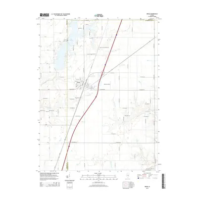
2015 Map of Neoga
USGS Topo · Published 2015About this map
Neoga sits at the heart of this central Illinois landscape, a town defined by its intersection with the rail lines that historically shaped the region's development. The map reveals a dense concentration of cemeteries that speak to the long history of settlement here, including the notably named Illinois Central Railroad Cem, Neoga Railroad Crossing Cem, and the Illinois Central Pioneer Cem. To the west, the sprawling waters of Lake Mattoon reach into the quadrangle, with its irregular shoreline creating numerous inlets near Concord Cem and Lockhart Cem. The terrain is etched by several drainage systems, most notably Copperas Cr and Long Point Cr, which wind through the rural acreage surrounding the municipal center. The presence of Williamson Airport and a grid of well-defined county roads, such as E 1000 North Rd, underscores the area's modern infrastructure while maintaining its established agricultural character.
Find a feature on this map
75 named features on this map. Tap any name to fly to it.
Don’t see what you’re looking for? This feature index may not catch every label — zoom into the map to look around manually.
Map Details
Editions of this 2015 Neoga Map
This is the sole edition of this map. No revisions or reprints were ever made.
Other maps of this area

1934 · Mattoon
USGS Topo · 1:62,500

1937 · Mattoon
USGS Topo · 1:62,500

1947 · Stewardson
USGS Topo · 1:62,500

1949 · Stewardson
USGS Topo · 1:62,500

1950 · Effingham
USGS Topo · 1:62,500

1951 · Effingham
USGS Topo · 1:62,500

1953 · Teutopolis
USGS Topo · 1:62,500

1958 · Decatur
USGS Topo · 1:250,000

1961 · Decatur
USGS Topo · 1:250,000
1981 · Stewardson East
USGS Topo · 1:24,000