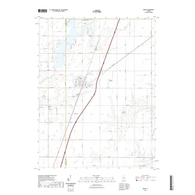
2021 Map of Neoga
USGS Topo · Published 2021About this map
Neoga serves as the central hub of this Cumberland County landscape, where the town’s grid meets a network of local roads and watercourses. A notable concentration of cemeteries, such as the Illinois Central Railroad Cem and Zion Chapel Cem, provides a map for genealogists tracing family roots near the Coles Co and Shelby Co lines. To the northwest, the waters of Lake Mattoon intersect with several drainages, including Clear Creek DR and Brush Creek.
Find a feature on this map
70 named features on this map. Tap any name to fly to it.
Don’t see what you’re looking for? This feature index may not catch every label — zoom into the map to look around manually.
Map Details
Editions of this 2021 Neoga Map
This is the sole edition of this map. No revisions or reprints were ever made.
Other maps of this area

1934 · Mattoon
USGS Topo · 1:62,500

1937 · Mattoon
USGS Topo · 1:62,500

1947 · Stewardson
USGS Topo · 1:62,500

1949 · Stewardson
USGS Topo · 1:62,500

1950 · Effingham
USGS Topo · 1:62,500

1951 · Effingham
USGS Topo · 1:62,500

1953 · Teutopolis
USGS Topo · 1:62,500

1958 · Decatur
USGS Topo · 1:250,000

1961 · Decatur
USGS Topo · 1:250,000
1981 · Stewardson East
USGS Topo · 1:24,000