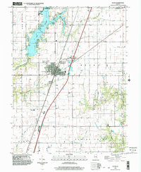
1998 Map of Neoga
USGS Topo · Published 2003About this map
Neoga serves as a central hub on this Central Illinois prairie landscape, where the Illinois Central Railroad and Interchange 177 intersect. The town's layout is closely tied to its transit history, showing the transition from rail-dependent industry to highway accessibility. To the northwest, the fingers of Lake Mattoon extend into the territory, supported by infrastructure like the Water Intake Pump, a Campground, and a Boat Ramp.
Find a feature on this map
32 named features on this map. Tap any name to fly to it.
Don’t see what you’re looking for? This feature index may not catch every label — zoom into the map to look around manually.
Map Details
Editions of this 1998 Neoga Map
This is the sole edition of this map. No revisions or reprints were ever made.
Other maps of this area

1934 · Mattoon
USGS Topo · 1:62,500

1937 · Mattoon
USGS Topo · 1:62,500

1947 · Stewardson
USGS Topo · 1:62,500

1949 · Stewardson
USGS Topo · 1:62,500

1950 · Effingham
USGS Topo · 1:62,500

1951 · Effingham
USGS Topo · 1:62,500

1953 · Teutopolis
USGS Topo · 1:62,500

1958 · Decatur
USGS Topo · 1:250,000

1961 · Decatur
USGS Topo · 1:250,000
1981 · Stewardson East
USGS Topo · 1:24,000