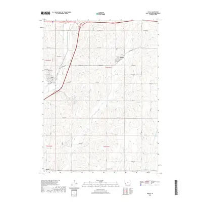
2018 Map of Neola
USGS Topo · Published 2018About this map
Neola and Minden anchor this rural Pottawattamie County landscape, where the agricultural grid is deeply etched by the winding paths of Mosquito Creek and Keg Cr. The map preserves the spatial arrangement of several local burial grounds, including the Saint Patricks Catholic Cem and the Neola Cem, providing essential points of reference for genealogists tracking families in the region. To the south, the smaller communities of Bentley and York Center mark the quiet intersections of a road network named for local flora and landmarks, such as Rosewood Rd and Pinoak Rd. The terrain is defined by the drainage systems of Little Silver Cr and Middle Silver Cr, which cut through the farm plots. This survey reflects the enduring character of Iowa’s western prairie settlements, documenting the persistence of small-town centers amidst a vast network of section-line roads and family-owned acreage.
Find a feature on this map
34 named features on this map. Tap any name to fly to it.
Don’t see what you’re looking for? This feature index may not catch every label — zoom into the map to look around manually.
Map Details
Editions of this 2018 Neola Map
This is the sole edition of this map. No revisions or reprints were ever made.
Other maps of this area

1954 · Omaha
USGS Topo · 1:250,000

1956 · Underwood
USGS Topo · 1:24,000

1956 · Neola
USGS Topo · 1:24,000

1956 · Mc Clelland
USGS Topo · 1:24,000

1957 · Omaha
USGS Topo · 1:250,000

1957 · Taylor
USGS Topo · 1:24,000

1958 · Omaha
USGS Topo · 1:250,000

1963 · Avoca NW
USGS Topo · 1:24,000

1963 · Oakland
USGS Topo · 1:24,000
1978 · Hard Scratch
USGS Topo · 1:24,000