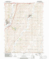
1994 Map of Neola
USGS Topo · Published 1994About this map
The town of Neola serves as a primary hub in this Pottawattamie County landscape, situated where the waters of Mosquito Creek wind through the terrain. The map captures the region's transition into the late 20th century, balanced between established rail-line heritage and the modern interstate system, evidenced by Interchange 28 and Interchange 27. To the east, the community of Minden is clearly delineated, while the smaller settlements of Bentley and York Center anchor the southern reaches of the quadrangle.
Find a feature on this map
18 named features on this map. Tap any name to fly to it.
Don’t see what you’re looking for? This feature index may not catch every label — zoom into the map to look around manually.
Map Details
Editions of this 1994 Neola Map
This is the sole edition of this map. No revisions or reprints were ever made.
Other maps of this area

1954 · Omaha
USGS Topo · 1:250,000

1956 · Underwood
USGS Topo · 1:24,000

1956 · Neola
USGS Topo · 1:24,000

1956 · Mc Clelland
USGS Topo · 1:24,000

1957 · Omaha
USGS Topo · 1:250,000

1957 · Taylor
USGS Topo · 1:24,000

1958 · Omaha
USGS Topo · 1:250,000

1963 · Avoca NW
USGS Topo · 1:24,000

1963 · Oakland
USGS Topo · 1:24,000
1978 · Hard Scratch
USGS Topo · 1:24,000