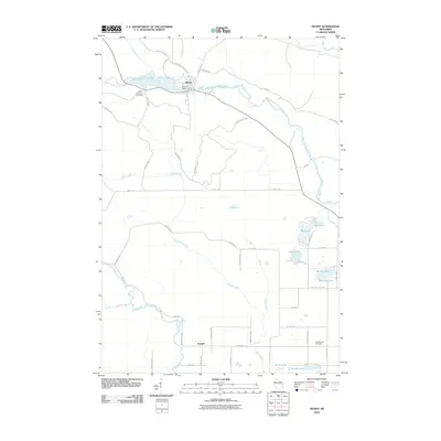
2010 Map of Neopit
USGS Topo · Published 2010About this map
The West Branch Wolf River flows through the heart of the settlement at Neopit, where the Neopit Dam and the expansive Neopit Millpond 108 reflect the community's relationship with the water. The landscape is defined by a dense network of forest roads like BIA Road 58 and Rice Bed Rd that navigate the varied terrain and waterways. To the south, the village of Morgan sits near the confluence of the Red River and Miller Creek. Local history is anchored by Saint Anthonys Cemetery and Red Springs Cemetery, while the northern reaches of the quadrangle feature natural landmarks such as Rainbow Falls and Peavey Falls. This area of Menominee County shows a clear pattern of lakes and wetlands, including Lost Lake and Mission Lake, which historically supported local subsistence and timber activity.
Find a feature on this map
53 named features on this map. Tap any name to fly to it.
Don’t see what you’re looking for? This feature index may not catch every label — zoom into the map to look around manually.
Map Details
Editions of this 2010 Neopit Map
This is the sole edition of this map. No revisions or reprints were ever made.
Other maps of this area

1952 · White Lake
USGS Topo · 1:48,000

1952 · Langlade
USGS Topo · 1:48,000

1954 · Gresham
USGS Topo · 1:48,000

1954 · Shawano
USGS Topo · 1:48,000

1954 · Iron Mountain
USGS Topo · 1:250,000

1955 · Green Bay
USGS Topo · 1:250,000

1959 · Iron Mountain
USGS Topo · 1:250,000

1964 · Shawano
USGS Topo · 1:62,500

1964 · Gresham
USGS Topo · 1:62,500
1973 · Perote Lake
USGS Topo · 1:24,000