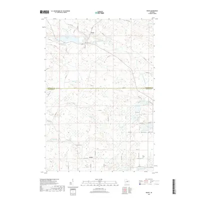
2018 Map of Neopit
USGS Topo · Published 2018About this map
Neopit serves as the primary hub of this landscape at the confluence of the W Br Wolf River and Tourtillotte Cr. The settlement is defined by its relationship with the water, anchored by the Neopit Millpond and the larger West Branch Wolf River that winds eastward toward Rainbow Falls and Peavey Falls. To the south, the village of Morgan sits near the border of Menominee Co and Shawano Co, marking a transition toward the lake-strewn southern terrain. This region is dense with water bodies including Beaulieu Lake, Island Lake, and Mission Lake, each connected by a network of rural routes like BIA Rte 38 and Co Rd G. For genealogists, the inclusion of Saint Anthonys Cem near the northern millpond and Red Springs Cem to the southeast provides specific points of interest for tracing local family histories.
Find a feature on this map
66 named features on this map. Tap any name to fly to it.
Don’t see what you’re looking for? This feature index may not catch every label — zoom into the map to look around manually.
Map Details
Editions of this 2018 Neopit Map
This is the sole edition of this map. No revisions or reprints were ever made.
Other maps of this area

1952 · White Lake
USGS Topo · 1:48,000

1952 · Langlade
USGS Topo · 1:48,000

1954 · Gresham
USGS Topo · 1:48,000

1954 · Shawano
USGS Topo · 1:48,000

1954 · Iron Mountain
USGS Topo · 1:250,000

1955 · Green Bay
USGS Topo · 1:250,000

1959 · Iron Mountain
USGS Topo · 1:250,000

1964 · Shawano
USGS Topo · 1:62,500

1964 · Gresham
USGS Topo · 1:62,500
1973 · Perote Lake
USGS Topo · 1:24,000