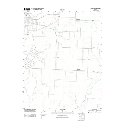
2012 Map of Neosho East
USGS Topo · Published 2012About this map
Neosho occupies the northwest corner of this survey, where the landscape is defined by a dense network of water sources including the notable Big Spring. Moving east from the city, the terrain transitions into a rural area marked by the winding courses of Hickory Creek and Bullskin Creek. This region is punctuated by small, established communities such as Aroma, Sweetwater, and Christopher, which are connected by a grid of county roads and highways like Highway H. The presence of multiple springs, including Hearrell Spring, McMahan Spring, and Elm Spring, suggests a landscape shaped by its hydrology, long supporting local agriculture and small-scale settlement. Genealogists may find value in the clear identification of local burial grounds like Elm Spring Cemetery and Maness Cemetery, while the southern reaches of the map include the descriptively named Pottershop Hollow.
Find a feature on this map
72 named features on this map. Tap any name to fly to it.
Don’t see what you’re looking for? This feature index may not catch every label — zoom into the map to look around manually.
Map Details
Editions of this 2012 Neosho East Map
This is the sole edition of this map. No revisions or reprints were ever made.
Other maps of this area

1916 · Neosho
USGS Topo · 1:62,500

1940 · Noel
USGS Topo · 1:62,500

1941 · Rocky Comfort
USGS Topo · 1:62,500

1943 · Ritchey
USGS Topo · 1:62,500

1943 · Noel
USGS Topo · 1:62,500

1943 · Rocky Comfort
USGS Topo · 1:62,500

1954 · Tulsa
USGS Topo · 1:250,000

1958 · Tulsa
USGS Topo · 1:250,000

1963 · Tulsa
USGS Topo · 1:250,000
1972 · Granby
USGS Topo · 1:24,000