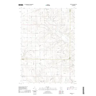
2018 Map of Nerike Hill
USGS Topo · Published 2018About this map
Plum City and the unincorporated community of Lund anchor this survey of the driftless-style borderlands between Pierce and Pepin counties. The landscape is defined by its dramatic relief, where steep coulees and valleys like Brunner Valley and Stony Coulee carve into the high plateaus. This topography dictated the settlement patterns and road networks, forcing homesteads and small family-run airfields like Airwolfe Airport onto the relatively flat ridge tops. Genealogists will find a wealth of local burial sites documenting the area's rural heritage, including the Lund Methodist Cem and the Free Home Cem. The drainage patterns of Plum Cr and its tributaries, such as Little Plum Cr, illustrate the complex watershed that flows toward the nearby Mississippi River valley. Numerous named landmarks like Nerike Hill and Alberts Bluff provide specific orientation for those tracing historic land tracts.
Find a feature on this map
103 named features on this map. Tap any name to fly to it.
Don’t see what you’re looking for? This feature index may not catch every label — zoom into the map to look around manually.
Map Details
Editions of this 2018 Nerike Hill Map
This is the sole edition of this map. No revisions or reprints were ever made.
Other maps of this area

1932 · Wabasha
USGS Topo · 1:62,500

1935 · Arkansaw
USGS Topo · 1:48,000

1940 · Maiden Rock
USGS Topo · 1:62,500

1941 · Arkansaw
USGS Topo · 1:62,500

1942 · Arkansaw
USGS Topo · 1:62,500

1950 · Maiden Rock
USGS Topo · 1:62,500

1951 · Wabasha
USGS Topo · 1:62,500

1951 · Lake City
USGS Topo · 1:62,500

1953 · Saint Paul
USGS Topo · 1:250,000

1959 · Saint Paul
USGS Topo · 1:250,000