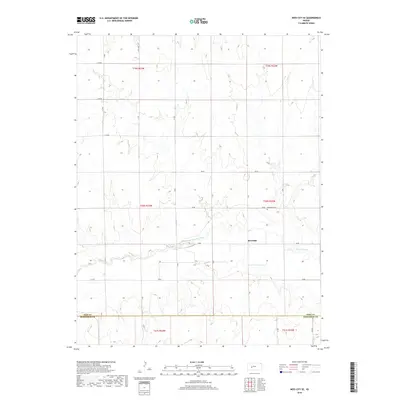
2018 Map of Ness City SE
USGS Topo · Published 2018About this map
The Pawnee River meanders across this rural landscape in western Kansas, anchoring the settlement of Riverside. This 2018 survey reveals the organized grid of section lines and range roads that define the High Plains agricultural economy. Near the river's path, the Riverside Cem serves as a significant landmark for local genealogy and history, situated just north of the 20 RD corridor. The southern portion of the map is defined by the Ness Co Hodgeman Co boundary line, marking the transition between administrative districts. The terrain is characterized by subtle elevation changes and drainages that feed into the central river system, with a network of designated routes like 40 RD and S W RD connecting the scattered homesteads and fields across townships like t19s r23w and t20s r22w.
Find a feature on this map
29 named features on this map. Tap any name to fly to it.
Don’t see what you’re looking for? This feature index may not catch every label — zoom into the map to look around manually.
Map Details
Editions of this 2018 Ness City SE Map
This is the sole edition of this map. No revisions or reprints were ever made.
Other maps of this area

1892 · Ness
USGS Topo · 1:125,000

1894 · Ness
USGS Topo · 1:125,000

1955 · Great Bend
USGS Topo · 1:250,000

1957 · Great Bend
USGS Topo · 1:250,000

1958 · Great Bend
USGS Topo · 1:250,000

1966 · Ness City
USGS Topo · 1:24,000

1966 · Ness City NE
USGS Topo · 1:24,000
1966 · Bazine
USGS Topo · 1:24,000

1970 · Hanston NW
USGS Topo · 1:24,000

1970 · Jetmore NE
USGS Topo · 1:24,000