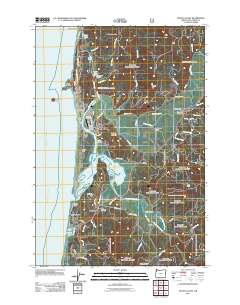
2011 Map of Nestucca Bay
USGS Topo · Published 2011About this map
Nestucca Bay dominates the central coastline of this Tillamook County survey, where the Nestucca River and Little Nestucca River converge before meeting the Pacific Ocean. This coastal landscape is defined by its distinct landforms, from the prominent Haystack Rock and Cape Kiwanda in the north to the North Spit protecting the bay's entrance. The settlement pattern reflects a mix of maritime proximity and inland river valley life, with Pacific City and Woods clustered near the river mouth, while Cloverdale and Meda sit further upriver.
Find a feature on this map
77 named features on this map. Tap any name to fly to it.
Don’t see what you’re looking for? This feature index may not catch every label — zoom into the map to look around manually.
Map Details
Editions of this 2011 Nestucca Bay Map
This is the sole edition of this map. No revisions or reprints were ever made.
Other maps of this area

1941 · Nestucca Bay
USGS Topo · 1:62,500

1942 · Nestucca Bay
USGS Topo · 1:62,500

1942 · Tillamook
USGS Topo · 1:62,500

1948 · Vancouver
USGS Topo · 1:250,000

1950 · Vancouver
USGS Topo · 1:250,000

1950 · Vancouver
USGS Topo · 1:250,000

1955 · Hebo
USGS Topo · 1:62,500

1955 · Tillamook
USGS Topo · 1:62,500

1958 · Vancouver
USGS Topo · 1:250,000

1964 · Vancouver
USGS Topo · 1:250,000