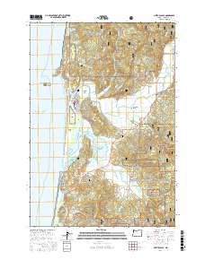
2017 Map of Nestucca Bay
USGS Topo · Published 2017About this map
Pacific City and Woods occupy the central coastal stretch where the Nestucca River winds through extensive wetlands toward Nestucca Bay. The landscape is defined by the tension between the coastal dunes of Cape Kiwanda and the heavily forested slopes of the Siuslaw National Forest to the east. Several small settlements including Cloverdale, Oretown, and Meda are situated along the river valleys and highways, serving as inland hubs for this maritime and agricultural region. Significant conservation areas like the Nestucca Bay National Wildlife Refuge protect the estuarine environment near Brooten Mtn. Local genealogy and land use can be traced through sites like the IOOF Cem and the Union Cem, alongside distinctive terrain markers such as Haystack Rock and Alderman Butte.
Find a feature on this map
84 named features on this map. Tap any name to fly to it.
Don’t see what you’re looking for? This feature index may not catch every label — zoom into the map to look around manually.
Map Details
Editions of this 2017 Nestucca Bay Map
This is the sole edition of this map. No revisions or reprints were ever made.
Other maps of this area

1941 · Nestucca Bay
USGS Topo · 1:62,500

1942 · Nestucca Bay
USGS Topo · 1:62,500

1942 · Tillamook
USGS Topo · 1:62,500

1948 · Vancouver
USGS Topo · 1:250,000

1950 · Vancouver
USGS Topo · 1:250,000

1950 · Vancouver
USGS Topo · 1:250,000

1955 · Hebo
USGS Topo · 1:62,500

1955 · Tillamook
USGS Topo · 1:62,500

1958 · Vancouver
USGS Topo · 1:250,000

1964 · Vancouver
USGS Topo · 1:250,000