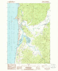
1985 Map of Nestucca Bay
USGS Topo · Published 1986About this map
Nestucca Bay and its complex tidal estuary dominate this coastal landscape, where the Nestucca River and Little Nestucca River meet the Pacific. The settlements of Pacific City and Woods are established near the northern mouth of the bay, sheltered behind the North Spit and the distinctive sandstone headland of Cape Kiwanda. Further inland, the map captures the rural community of Cloverdale along the river and Oretown to the south, reflecting a settlement pattern tied closely to the fertile river valleys and coastal access.
Find a feature on this map
54 named features on this map. Tap any name to fly to it.
Don’t see what you’re looking for? This feature index may not catch every label — zoom into the map to look around manually.
Map Details
Editions of this 1985 Nestucca Bay Map
This is the sole edition of this map. No revisions or reprints were ever made.
Other maps of this area

1941 · Nestucca Bay
USGS Topo · 1:62,500

1942 · Nestucca Bay
USGS Topo · 1:62,500

1942 · Tillamook
USGS Topo · 1:62,500

1948 · Vancouver
USGS Topo · 1:250,000

1950 · Vancouver
USGS Topo · 1:250,000

1950 · Vancouver
USGS Topo · 1:250,000

1955 · Hebo
USGS Topo · 1:62,500

1955 · Tillamook
USGS Topo · 1:62,500

1958 · Vancouver
USGS Topo · 1:250,000

1964 · Vancouver
USGS Topo · 1:250,000