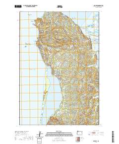
2020 Map of Netarts
USGS Topo · Published 2020About this map
Cape Meares stands as a prominent headland on this Oregon coast landscape, where the Pacific Ocean meets a complex network of bays and river mouths. The settlements of Oceanside and Netarts are central to the coastal topography, oriented around the protective stretch of Netarts Spit and the waters of Netarts Bay. To the north, the confluence of the Wilson River, Trask River, and Tillamook River creates a dynamic estuarine environment within Tillamook Bay, punctuated by distinctive landforms like Snag Island, Dry Stocking Island, and Sand Island. Offshore, the presence of Three Arch Rocks, Pyramid Rock, and Seal Rock highlights the area's maritime hazards and landmarks. Inland, the terrain is defined by a dense drainage system including Whiskey Creek, Fall Cr, and Tomlinson Cr, reflecting the region's steep coastal hydrology.
Find a feature on this map
88 named features on this map. Tap any name to fly to it.
Don’t see what you’re looking for? This feature index may not catch every label — zoom into the map to look around manually.
Map Details
Editions of this 2020 Netarts Map
This is the sole edition of this map. No revisions or reprints were ever made.
Other maps of this area

1937 · Nehalem
USGS Topo · 1:62,500

1942 · Tillamook
USGS Topo · 1:62,500

1943 · Nehalem
USGS Topo · 1:62,500

1948 · Vancouver
USGS Topo · 1:250,000

1950 · Vancouver
USGS Topo · 1:250,000

1950 · Vancouver
USGS Topo · 1:250,000

1955 · Nehalem
USGS Topo · 1:62,500

1955 · Tillamook
USGS Topo · 1:62,500

1958 · Vancouver
USGS Topo · 1:250,000

1964 · Vancouver
USGS Topo · 1:250,000