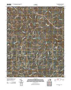
2010 Map of Nettleridge
USGS Topo · Published 2010About this map
The South Mayo River meanders through this portion of the Virginia and North Carolina borderlands, anchoring a landscape defined by small rural hubs and cross-road landmarks. Settlements like Coleville, Palmetto, and Nettleridge are connected by a network of local roads such as Ayers Orchard Rd and Corn Doss Rd. The map reveals a high concentration of community burial grounds, including High Point Cemetery, Big A Cemetery, and Nettle Ridge Cemetery, which serve as vital reference points for local genealogists.
Find a feature on this map
42 named features on this map. Tap any name to fly to it.
Don’t see what you’re looking for? This feature index may not catch every label — zoom into the map to look around manually.
Map Details
Editions of this 2010 Nettleridge Map
This is the sole edition of this map. No revisions or reprints were ever made.
Other maps of this area

1926 · Critz
USGS Topo · 1:48,000

1928 · Stuart
USGS Topo · 1:48,000

1928 · Critz
USGS Topo · 1:62,500

1931 · Stuart
USGS Topo · 1:62,500

1953 · Winston-Salem
USGS Topo · 1:250,000

1955 · Winston-Salem
USGS Topo · 1:250,000

1962 · Winston-Salem
USGS Topo · 1:250,000

1964 · Hanging Rock
USGS Topo · 1:24,000

1967 · Patrick Springs
USGS Topo · 1:24,000
1967 · Spencer
USGS Topo · 1:24,000