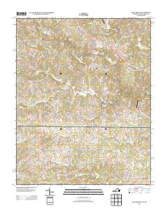
2013 Map of Nettleridge
USGS Topo · Published 2013About this map
Gilbert Mill and Nettleridge anchor this rural landscape along the Virginia and North Carolina border, where the terrain is defined by the winding course of the S Mayo River. The area is characterized by a dense network of small waterways, including Russell Cr, Spoon Cr, and Snow Cr, which have historically dictated the placement of homesteads and local commerce. Aviation footprints are visible through Collins Airport and Moorefield's Airstrip, reflecting the importance of private air travel in this part of the Piedmont. Many roads follow the traditional paths of family-named lanes and farm-to-market routes, such as Vias Orchard Rd and New Hope Church Rd, connecting small hubs like Moorefield Store and Oak Ridge. This survey provides a clear view of the modern rural interface, where large agricultural tracts meet local commercial points.
Find a feature on this map
134 named features on this map. Tap any name to fly to it.
Don’t see what you’re looking for? This feature index may not catch every label — zoom into the map to look around manually.
Map Details
Editions of this 2013 Nettleridge Map
This is the sole edition of this map. No revisions or reprints were ever made.
Other maps of this area

1926 · Critz
USGS Topo · 1:48,000

1928 · Stuart
USGS Topo · 1:48,000

1928 · Critz
USGS Topo · 1:62,500

1931 · Stuart
USGS Topo · 1:62,500

1953 · Winston-Salem
USGS Topo · 1:250,000

1955 · Winston-Salem
USGS Topo · 1:250,000

1962 · Winston-Salem
USGS Topo · 1:250,000

1964 · Hanging Rock
USGS Topo · 1:24,000

1967 · Patrick Springs
USGS Topo · 1:24,000
1967 · Spencer
USGS Topo · 1:24,000