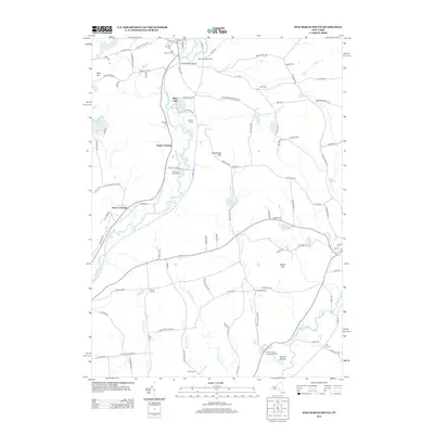
2013 Map of New Berlin South
USGS Topo · Published 2013About this map
The Unadilla River and its varied tributaries like Thorp Brook and Wharton Cr define this Central New York landscape, which remains largely agricultural and rural in the early 21st century. Several small community nodes and historic crossings persist, including Sages Crossing, Davis Crossing, and Church Corners. Genealogists will find particular value in the documentation of several burial sites, such as the Morris Family Burying Ground near Dimock Hollow and the Scribner Cem located south of Silver Lake. The map reveals a land of active farming and recreation, from the Waltzing Horse Farm in the north to the Riverbend Golf Course along the river banks. Prominent high points like Shacktown Mtn and Harris Hill overlook a network of county highways and named backroads like Poverty Ln and Shacktown Mountain Rd.
Find a feature on this map
107 named features on this map. Tap any name to fly to it.
Don’t see what you’re looking for? This feature index may not catch every label — zoom into the map to look around manually.
Map Details
Editions of this 2013 New Berlin South Map
This is the sole edition of this map. No revisions or reprints were ever made.
Other maps of this area

1910 · Hartwick
USGS Topo · 1:62,500

1910 · New Berlin
USGS Topo · 1:62,500

1912 · New Berlin
USGS Topo · 1:62,500

1912 · Hartwick
USGS Topo · 1:62,500

1915 · Oneonta
USGS Topo · 1:62,500

1915 · Unadilla
USGS Topo · 1:62,500

1918 · Unadilla
USGS Topo · 1:62,500

1918 · Oneonta
USGS Topo · 1:62,500

1943 · New Berlin North
USGS Topo · 1:24,000

1943 · New Berlin South
USGS Topo · 1:24,000