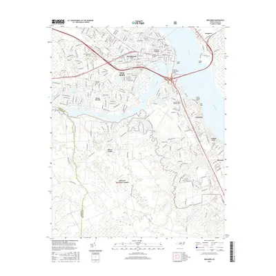
2016 Map of New Bern
USGS Topo · Published 2016About this map
New Bern sits at the prominent confluence of the Neuse River and Trent River, serving as a historic hub for maritime and overland transport in coastal North Carolina. This survey details the urban core and its neighboring residential districts like DeGraffenried Park and Craven Terrace, alongside the nearby town of Bridgeton across the Neuse. The landscape south of the city shifts into the dense wetlands of the Croatan National Forest and the Brice Creek Pocoson, where numerous small waterways like Jack Smith Creek and Lawson Creek drain into the primary river systems. Genealogists will find several significant burial grounds documented, including the historic Cedar Grove Cemetery and Greenwood Cemetery. The infrastructure of the mid-2010s is well-defined, showing the Coastal Carolina Regional Airport and the expansive Alfred A Cunningham Bridge connecting the riverside communities.
Find a feature on this map
41 named features on this map. Tap any name to fly to it.
Don’t see what you’re looking for? This feature index may not catch every label — zoom into the map to look around manually.
Map Details
Editions of this 2016 New Bern Map
This is the sole edition of this map. No revisions or reprints were ever made.
Other maps of this area

1901 · New Bern
USGS Topo · 1:62,500

1903 · New Bern
USGS Topo · 1:62,500

1942 · Maysville
USGS Topo · 1:62,500

1948 · Maysville
USGS Topo · 1:62,500

1949 · Havelock
USGS Topo · 1:24,000

1950 · Pollocksville
USGS Topo · 1:24,000

1950 · New Bern
USGS Topo · 1:24,000

1950 · Upper Broad Creek
USGS Topo · 1:24,000

1951 · Upper Broad Creek
USGS Topo · 1:24,000

1953 · Rocky Mount
USGS Topo · 1:250,000