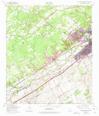
1958 Map of New Braunfels West
USGS Topo · Published 1975About this map
New Braunfels expands across the Comal and Guadalupe county lines in this mid-century topographic record, which documents the post-war growth of the city alongside its foundational landscapes. The map captures the significant industrial and recreational infrastructure of the era, from the sprawling grounds of Landa Park and its Golf Course to the limestone-heavy industrial site at Dittlinger. The transportation network is dominated by the Missouri Pacific and Missouri Kansas Texas railroads, which parallel the distinct course of Dry Comal Creek. To the west, the landscape transitions into ranch land and residential developments like Landa Park Highlands and Jentsch Acres. Researchers will find of particular interest the location of the Danville (Site), as well as family-named landmarks like Krueger Ranch and the established Seele Sch.
Find a feature on this map
28 named features on this map. Tap any name to fly to it.
Don’t see what you’re looking for? This feature index may not catch every label — zoom into the map to look around manually.
Map Details
Editions of this 1958 New Braunfels West Map
2 editions found
Other maps of this area

1920 · Smithsons Valley
USGS Topo · 1:62,500

1924 · New Braunfels No 4
USGS Topo · 1:48,000

1925 · New Braunfels No 1
USGS Topo · 1:48,000

1925 · Hunter No 3
USGS Topo · 1:48,000

1927 · New Braunfels
USGS Topo · 1:62,500

1927 · Smithson Valley
USGS Topo · 1:62,500

1929 · Hunter
USGS Topo · 1:62,500

1929 · Smithson Valley
USGS Topo · 1:62,500

1940 · Smithson Valley
USGS Topo · 1:62,500

1953 · Schertz
USGS Topo · 1:24,000
Featured Places
- New Braunfels, TX
- Schertz, TX
- Santa Clara, TX
- Bavarian Village, New Braunfels
- Landa Park Estates, New Braunfels