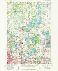
1955 Map of New Brighton
USGS Topo · Published 1959About this map
Twin Cities Arsenal occupies a massive footprint at the heart of this mid-1950s survey, illustrating the significant military-industrial presence north of the metropolitan area during the Cold War. The landscape shows a region in transition, where suburban expansion in New Brighton and Shoreview meets the rural marshlands and lakes of the north. Significant water management infrastructure is evident through the St Paul Waterworks and the Abandoned Aqueduct, which once channeled water from the chain of lakes toward the city. To the north, the Carlos Avery State Game Refuge and Public Hunting Grounds preserves a wilder character near Columbus, contrasting with the burgeoning transportation hubs like the Anoka County Airport. Genealogists may find interest in local landmarks such as the Red Brick Sch, Twitchel Cem, and several named country churches that served these evolving communities.
Find a feature on this map
134 named features on this map. Tap any name to fly to it.
Don’t see what you’re looking for? This feature index may not catch every label — zoom into the map to look around manually.
Map Details
Editions of this 1955 New Brighton Map
This is the sole edition of this map. No revisions or reprints were ever made.
Other maps of this area

1896 · Minneapolis
USGS Topo · 1:62,500

1896 · St. Paul
USGS Topo · 1:62,500

1901 · Minneapolis
USGS Topo · 1:62,500

1902 · White Bear
USGS Topo · 1:62,500

1902 · Anoka
USGS Topo · 1:62,500

1916 · St. Francis
USGS Topo · 1:62,500

1919 · St. Francis
USGS Topo · 1:62,500

1946 · Hudson
USGS Topo · 1:62,500

1948 · Stillwater
USGS Topo · 1:62,500

1949 · Hudson
USGS Topo · 1:62,500