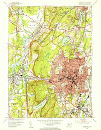
1953 Map of New Britain
USGS Topo · Published 1954About this map
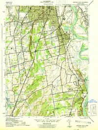
New Britain and its surrounding townships reflect a dense mid-century landscape of civic institutions and industrial infrastructure. The city center is dominated by an extensive network of schools and colleges, including the State Teachers College, Smalley Sch, and Elihu Burritt Jr High Sch, while religious and charitable landmarks like the Holy Family Monastery and the Klingberg Childrens Home dot the suburban fringes. To the west, the steep elevations of Rattlesnake Mtn and Bradley Mtn along the Metacomet Ridge create a natural barrier, punctuated by Cooks Gap. This topography necessitated the engineering of several local water sources, notably the Shuttle Meadow Reservoir and Plainville Reservoir. Transportation is defined by the New York New Haven and Hartford rail lines, which connect industrial hubs like Plainville and Kensington through the Berlin Sta.
Find a feature on this map
95 named features on this map. Tap any name to fly to it.
Don’t see what you’re looking for? This feature index may not catch every label — zoom into the map to look around manually.
Map Details
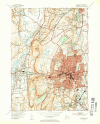
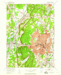
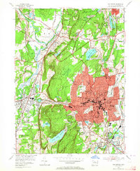
Editions of this 1953 New Britain Map
4 editions found
Other maps of this area

1892 · Hartford
USGS Topo · 1:62,500

1892 · Meriden
USGS Topo · 1:62,500

1892 · Granby
USGS Topo · 1:62,500

1893 · Middletown
USGS Topo · 1:62,500

1893 · Meriden
USGS Topo · 1:62,500

1906 · Farmington
USGS Topo · 1:125,000

1928 · Cromwell
USGS Topo · 1:24,000

1928 · Windsor
USGS Topo · 1:24,000
1944 · Hartford South
USGS Topo · 1:31,680

1945 · Hartford North
USGS Topo · 1:31,680