
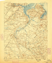
1893 Map of New Brunswick
USGS Topo · Published 1893About this map
The Raritan River and its complex network of tributaries define the landscape of Central New Jersey during the late nineteenth century. Industrial expansion is evident through a dense concentration of transit corridors, notably the Camden and Amboy Railroad and the New York and Long Branch Railroad, which facilitated movement between the growing hubs of New Brunswick and South Amboy. Outside these urban centers, the map documents a transition into a rural interior marked by small settlements like Rhode Hall, Matchaponix, and Hardenberg Corners. Significant institutional and cultural sites are visible, including the State Reform School near Jamesburg and the sprawling Monmouth Battle Ground near Freehold. The detailed mapping of waterways like Chesquakes Creek and the South River highlights the importance of drainage and water access for the region's clay and brick industries, represented by labels such as Edgar's Clay R.R. near the coast.
Find a feature on this map
86 named features on this map. Tap any name to fly to it.
Don’t see what you’re looking for? This feature index may not catch every label — zoom into the map to look around manually.
Map Details
Editions of this 1893 New Brunswick Map
2 editions found
Other maps of this area

1888 · Plainfield
USGS Topo · 1:62,500

1888 · Bordentown
USGS Topo · 1:62,500

1888 · New Brunswick
USGS Topo · 1:62,500

1888 · Princeton
USGS Topo · 1:62,500

1888 · Asbury Park
USGS Topo · 1:62,500

1888 · Cassville
USGS Topo · 1:62,500

1888 · Sandy Hook
USGS Topo · 1:62,500

1891 · Somerville
USGS Topo · 1:62,500

1893 · Bordentown
USGS Topo · 1:62,500

1893 · Plainfield
USGS Topo · 1:62,500