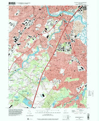
1995 Map of New Brunswick
USGS Topo · Published 2000About this map
The Raritan River and the Delaware and Raritan Canal anchor this mid-1990s landscape, illustrating the dense suburban and industrial evolution of central New Jersey. The city of New Brunswick sits at the heart of a complex transport network where the New Jersey Turnpike and the Garden State Parkway converge. Beyond the urban centers, the map details established neighborhoods like Highland Park and Milltown, along with numerous crossroads such as Paulas Corners and Tanners Corners. This era reveals a high density of civic infrastructure, including dozens of local schools like Kilmer Sch and Woodrow Wilson Sch. In the southern reach, the terrain opens into protected green spaces like Pigeon Swamp State Park and Ireland Brook County Park, preserving natural wetlands amidst the expanding residential corridors of Spotswood and East Spotswood.
Find a feature on this map
92 named features on this map. Tap any name to fly to it.
Don’t see what you’re looking for? This feature index may not catch every label — zoom into the map to look around manually.
Map Details
Editions of this 1995 New Brunswick Map
This is the sole edition of this map. No revisions or reprints were ever made.
Other maps of this area

1888 · Plainfield
USGS Topo · 1:62,500

1888 · New Brunswick
USGS Topo · 1:62,500

1888 · Princeton
USGS Topo · 1:62,500

1891 · Somerville
USGS Topo · 1:62,500

1893 · New Brunswick
USGS Topo · 1:62,500

1893 · Plainfield
USGS Topo · 1:62,500

1893 · Somerville
USGS Topo · 1:62,500

1894 · Princeton
USGS Topo · 1:62,500

1898 · Plainfield
USGS Topo · 1:62,500

1898 · Somerville
USGS Topo · 1:62,500