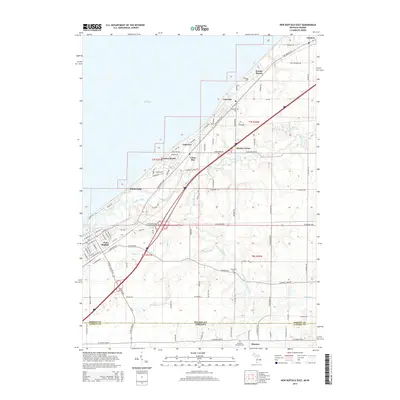
2014 Map of New Buffalo East
USGS Topo · Published 2014About this map
Lake Michigan dominates the northwestern edge of this modern survey, where a string of established lakeside communities and resort pockets define the shoreline. From Harbert and Turner Shores in the north through Lakeside, Union Pier, and down to New Buffalo, the landscape transitions from coastal bluffs and residential streets to the inland agricultural and wooded tracts of the state line region. The Galien River and its various branches, including the South Branch Galien River and S Br Galien River, carve drainage patterns through the terrain, passing near points like Hooks Corner and Gordon Beach.
Find a feature on this map
105 named features on this map. Tap any name to fly to it.
Don’t see what you’re looking for? This feature index may not catch every label — zoom into the map to look around manually.
Map Details
Editions of this 2014 New Buffalo East Map
This is the sole edition of this map. No revisions or reprints were ever made.
Other maps of this area

1930 · Three Oaks
USGS Topo · 1:62,500

1944 · Three Oaks
USGS Topo · 1:62,500

1953 · Chicago
USGS Topo · 1:250,000

1957 · Chicago
USGS Topo · 1:250,000

1958 · Michigan City East
USGS Topo · 1:24,000

1958 · Springville
USGS Topo · 1:24,000

1958 · New Carlisle
USGS Topo · 1:24,000
1969 · Michigan City East
USGS Topo · 1:24,000
1970 · New Buffalo West
USGS Topo · 1:24,000
1970 · New Buffalo East
USGS Topo · 1:24,000