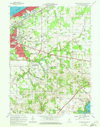
1969 Map of Michigan City East
USGS Topo · Published 1971About this map
Lake Michigan dominates the northwestern corner of this 1969 revision, where the coastal community of Long Beach sits tucked against the shoreline and its Pottawattomie Country Club. The landscape transitions from the urbanized grids of Michigan City to the more open, wetland-pocked terrain of Springfield and Coolspring townships. A dense network of transportation infrastructure defines the area’s industrial and commuter character, including the Chicago South Shore and South Bend and the Penn Central railroads. Genealogists and local historians can locate several family-named landmarks and smaller settlements like Waterford and Ambler, along with rural burial grounds such as Cross Cem and Sharp Cem. The map also captures specialized land uses near the southern border, notably the State Prison Farm and the Summit community, providing a clear record of the region’s development before the late 20th century.
Find a feature on this map
55 named features on this map. Tap any name to fly to it.
Don’t see what you’re looking for? This feature index may not catch every label — zoom into the map to look around manually.
Map Details
Editions of this 1969 Michigan City East Map
2 editions found
Other maps of this area

1930 · Three Oaks
USGS Topo · 1:62,500

1944 · Three Oaks
USGS Topo · 1:62,500

1953 · Westville
USGS Topo · 1:24,000

1953 · Michigan City West
USGS Topo · 1:24,000

1953 · Chicago
USGS Topo · 1:250,000

1957 · Chicago
USGS Topo · 1:250,000

1958 · Michigan City East
USGS Topo · 1:24,000

1958 · La Porte East
USGS Topo · 1:24,000

1958 · Springville
USGS Topo · 1:24,000
1961 · La Porte West
USGS Topo · 1:24,000