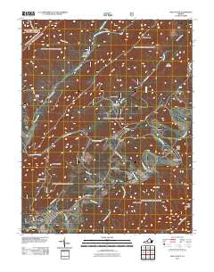
2011 Map of New Castle
USGS Topo · Published 2011About this map
New Castle sits at the confluence of Johns Creek and Craig Creek in this 2011 survey, serving as a hub for a landscape defined by sharp ridges and deep water gaps. The map reveals the historical and recreational layers of the valley, from the industry-marked sites of Fenwick Mine and Fenwick Mines Campground to the medicinal history implied by Virginia Mineral Springs. Settlement patterns follow the winding path of Barbours Creek, where small communities like Marshalltown and the village of Barbours Creek are established. High points such as Bald Mountain and Broad Run Mountain flank the valley floors, while Camp Easter Seal and The Pines Campground highlight the area's modern role as a destination for outdoor activity. The presence of The Pines Horse Corral and various forest service routes indicates a landscape managed for both preservation and accessibility.
Find a feature on this map
62 named features on this map. Tap any name to fly to it.
Don’t see what you’re looking for? This feature index may not catch every label — zoom into the map to look around manually.
Map Details
Editions of this 2011 New Castle Map
This is the sole edition of this map. No revisions or reprints were ever made.
Other maps of this area

1887 · Lewisburg
USGS Topo · 1:125,000

1890 · Roanoke
USGS Topo · 1:125,000

1890 · Christiansburg
USGS Topo · 1:125,000

1891 · Roanoke
USGS Topo · 1:125,000

1891 · Lewisburg
USGS Topo · 1:125,000

1894 · Natural Bridge
USGS Topo · 1:125,000

1913 · Eagle Rock
USGS Topo · 1:48,000

1915 · Eagle Rock
USGS Topo · 1:62,500

1929 · Roanoke
USGS Topo · 1:48,000

1929 · Salem
USGS Topo · 1:48,000