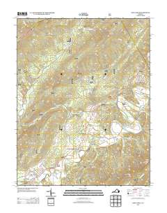
2013 Map of New Castle
USGS Topo · Published 2013About this map
New Castle serves as the primary hub of this 2013 survey, situated where Johns Cr and Craig Cr converge at the foot of Little Mountain. This Virginia landscape is defined by the narrow, fertile Craig Creek Valley, which supports several small rural settlements such as Charlton, Given, and Barbours Creek. The area's legacy as a destination for healing and industry is preserved through labels for Virginia Mineral Springs and the Fenwick Mines Campground, indicating the deep-rooted connections between the local geology and human development.
Find a feature on this map
38 named features on this map. Tap any name to fly to it.
Don’t see what you’re looking for? This feature index may not catch every label — zoom into the map to look around manually.
Map Details
Editions of this 2013 New Castle Map
This is the sole edition of this map. No revisions or reprints were ever made.
Other maps of this area

1887 · Lewisburg
USGS Topo · 1:125,000

1890 · Roanoke
USGS Topo · 1:125,000

1890 · Christiansburg
USGS Topo · 1:125,000

1891 · Roanoke
USGS Topo · 1:125,000

1891 · Lewisburg
USGS Topo · 1:125,000

1894 · Natural Bridge
USGS Topo · 1:125,000

1913 · Eagle Rock
USGS Topo · 1:48,000

1915 · Eagle Rock
USGS Topo · 1:62,500

1929 · Roanoke
USGS Topo · 1:48,000

1929 · Salem
USGS Topo · 1:48,000