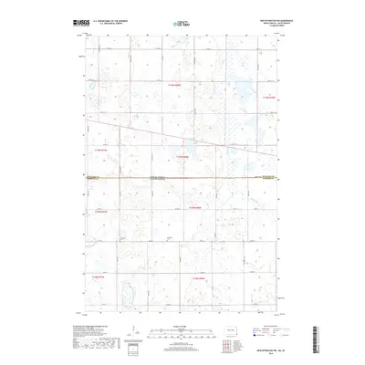
2018 Map of New Effington NW
USGS Topo · Published 2018About this map
North Dakota and South Dakota meet at a jurisdictional crossroad where the Richland and Roberts county line aligns with the state boundary. This prairie landscape is defined by the slow-moving drainage of the Big Slough, which meanders across the northeast quadrant. Local history is anchored by the presence of the Thompson Cem and Bohemian Cem, two small burial grounds that represent early family and community ties to the land. The area is laid out in a strict grid of section lines and gravel roads, including Co RD 25 and Co RD 21, which connect isolated homesteads across the townships of t129n r50w and t128n r51w.
Find a feature on this map
21 named features on this map. Tap any name to fly to it.
Don’t see what you’re looking for? This feature index may not catch every label — zoom into the map to look around manually.
Map Details
Editions of this 2018 New Effington NW Map
This is the sole edition of this map. No revisions or reprints were ever made.
Other maps of this area

1904 · Wahpeton
USGS Topo · 1:125,000

1907 · Wyndmere
USGS Topo · 1:125,000

1917 · New Effington
USGS Topo · 1:62,500

1953 · Milbank
USGS Topo · 1:250,000

1953 · Fargo
USGS Topo · 1:250,000

1956 · Fargo
USGS Topo · 1:250,000

1958 · Milbank
USGS Topo · 1:250,000

1964 · Hankinson
USGS Topo · 1:24,000

1964 · Hankinson SE
USGS Topo · 1:24,000
1964 · Swan Lake
USGS Topo · 1:24,000