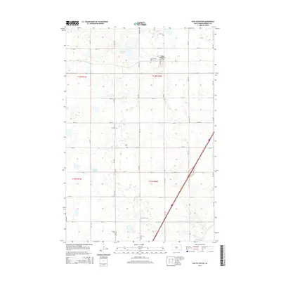
2015 Map of New Effington
USGS Topo · Published 2015About this map
New Effington serves as the primary hub in this corner of Roberts County, South Dakota, situated at the intersection of CR-8 and 105th St. The surrounding landscape is a testament to the region's Lutheran and Scandinavian heritage, evidenced by a high density of rural burial grounds scattered across the township grid. These sites, including Faith Cem, Zions Cem, and Scandia Cem, mark the historic center points of community life outside the main town site. Natural depressions in the terrain are filled by Dobberstien Slough and Knebel Slough, which break the regular pattern of section lines. This 2015 survey reflects the enduring agricultural layout of the Lake Traverse District, where local roads like 462nd Ave and 112th St connect isolated farmsteads to the commercial center at New Effington.
Find a feature on this map
28 named features on this map. Tap any name to fly to it.
Don’t see what you’re looking for? This feature index may not catch every label — zoom into the map to look around manually.
Map Details
Editions of this 2015 New Effington Map
This is the sole edition of this map. No revisions or reprints were ever made.
Other maps of this area

1916 · Peever
USGS Topo · 1:62,500

1917 · New Effington
USGS Topo · 1:62,500

1918 · Peever
USGS Topo · 1:62,500

1953 · Milbank
USGS Topo · 1:250,000

1958 · Milbank
USGS Topo · 1:250,000
1964 · Claire City NE
USGS Topo · 1:24,000

1964 · Claire City
USGS Topo · 1:24,000

1970 · Sisseton
USGS Topo · 1:24,000
1971 · Peever NW
USGS Topo · 1:24,000
1971 · Peever NE
USGS Topo · 1:24,000