
1954 Map of New Franken
USGS Topo · Published 1956About this map
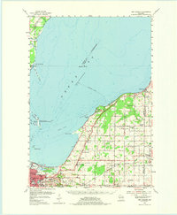
Green Bay dominates the western half of this mid-century survey, with the city of Green Bay occupying the southwestern corner and extending into the townships of Scott and Humboldt. The shoreline is characterized by prominent features like Point au Sable, Red Banks, and the protective reach of Little Tail Point. Inland, the landscape is defined by a dense network of local landmarks, including many parochial and public schools such as Bay Ridge Sch and Mount May Sch.
Find a feature on this map
55 named features on this map. Tap any name to fly to it.
Don’t see what you’re looking for? This feature index may not catch every label — zoom into the map to look around manually.
Map Details
Editions of this 1954 New Franken Map
2 editions found
Other maps of this area

1952 · Casco
USGS Topo · 1:62,500

1954 · De Pere
USGS Topo · 1:62,500

1954 · Kewaunee
USGS Topo · 1:62,500

1954 · Green Bay West
USGS Topo · 1:24,000

1954 · Denmark
USGS Topo · 1:62,500

1954 · De Pere
USGS Topo · 1:24,000

1954 · Green Bay East
USGS Topo · 1:24,000

1954 · Manitowoc
USGS Topo · 1:250,000

1954 · Bellevue
USGS Topo · 1:24,000

1954 · Green Bay
USGS Topo · 1:62,500