
1963 Map of New Greenleaf
USGS Topo · Published 1964About this map
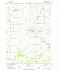
Ivanhoe and New Greenleaf anchor this agricultural landscape in Michigan’s Thumb region during the early 1960s. The terrain is defined by an extensive network of drainage systems such as the Sebewaing Drain and McLean Drain, which were essential for maintaining the productivity of the local farmland. The Chesapeake and Ohio RR cuts through the area, facilitating the movement of goods in a rural economy where grain and gravel were paramount. Local community life is evidenced by numerous one-room schoolhouses and rural parishes, including McIntyre School and St Columbkille Church. Along the southern border, the North Branch Cass River and South Fork Cass River converge, providing a natural break in the grid-based road system. This survey also records the industrial footprint of the time, noting several Gravel Pits and a prominent Radio Tower that stand as landmarks among the scattered farmsteads.
Find a feature on this map
68 named features on this map. Tap any name to fly to it.
Don’t see what you’re looking for? This feature index may not catch every label — zoom into the map to look around manually.
Map Details
Editions of this 1963 New Greenleaf Map
This is the sole edition of this map. No revisions or reprints were ever made.
Other maps of this area

1954 · Flint
USGS Topo · 1:250,000

1958 · Flint
USGS Topo · 1:250,000

1963 · Ubly
USGS Topo · 1:24,000

1963 · Cass City
USGS Topo · 1:24,000

1963 · Shabbona
USGS Topo · 1:24,000

1963 · Gagetown
USGS Topo · 1:24,000

1963 · Argyle
USGS Topo · 1:24,000

1970 · Bad Axe West
USGS Topo · 1:24,000
1970 · Elkton
USGS Topo · 1:24,000
1970 · Bad Axe East
USGS Topo · 1:24,000