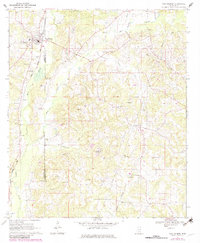
1970 Map of New Hebron
USGS Topo · Published 1982About this map
New Hebron serves as the primary hub of this landscape, situated along the Illinois Central Gulf railroad line. The settlement pattern is defined by rural road networks that connect smaller locales like Hebron and Grange across the border of Lawrence and Jefferson Davis Counties. This 1970s era documentation, with purple revisions from 1980, reveals a landscape where traditional community markers like St Marys Church and Zion Hill Church sit alongside a developing industrial footprint. Extensive Gravel Pits and an expansive Oil and Gas Field are prominent, particularly in the eastern sections near the Gwinville Branch. The drainage of Fiddlers Creek and the West Prong of Silver Creek carve through the terrain, which is dotted with numerous family-named burial grounds including Weathersby Cemetery and Dampeer Cemetery, offering a detailed view of the region's genealogical heritage.
Find a feature on this map
43 named features on this map. Tap any name to fly to it.
Don’t see what you’re looking for? This feature index may not catch every label — zoom into the map to look around manually.
Map Details
Editions of this 1970 New Hebron Map
2 editions found
Other maps of this area

1953 · Hattiesburg
USGS Topo · 1:250,000

1953 · Natchez
USGS Topo · 1:250,000

1956 · Natchez
USGS Topo · 1:250,000

1958 · Hattiesburg
USGS Topo · 1:250,000

1959 · Natchez
USGS Topo · 1:250,000

1970 · Prentiss West
USGS Topo · 1:24,000

1970 · Monticello
USGS Topo · 1:24,000

1970 · New Hebron
USGS Topo · 1:24,000

1970 · Prentiss East
USGS Topo · 1:24,000

1970 · Mount Carmel
USGS Topo · 1:24,000