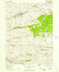
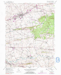
1956 Map of New Holland
USGS Topo · Published 1957About this map
New Holland serves as the focal point of this Lancaster County landscape, where the Pennsylvania Railroad and Pennsylvania Highway 23 dictate the local rhythm of commerce and travel. The map reveals a dense network of rural infrastructure, from the small settlements of Blue Ball and Intercourse to a remarkable concentration of local education and faith centers such as Hickory Grove Sch and the Zeltenreich Ch. The southern portion of the sheet is dominated by the rise of Welsh Mountain, providing a distinct topographic break from the well-settled valley floors where Pequea Creek and Groff Creek navigate the agricultural fields.
Find a feature on this map
74 named features on this map. Tap any name to fly to it.
Don’t see what you’re looking for? This feature index may not catch every label — zoom into the map to look around manually.
Map Details
Editions of this 1956 New Holland Map
5 editions found
Other maps of this area

1904 · Coatesville
USGS Topo · 1:62,500

1905 · Honey Brook
USGS Topo · 1:62,500

1906 · Coatesville
USGS Topo · 1:62,500

1906 · New Holland
USGS Topo · 1:62,500

1907 · Honeybrook
USGS Topo · 1:62,500

1908 · New Holland
USGS Topo · 1:62,500

1912 · Quarryville
USGS Topo · 1:62,500

1918 · Coatesville
USGS Topo · 1:62,500

1941 · Honeybrook
USGS Topo · 1:62,500

1941 · New Holland
USGS Topo · 1:62,500
Featured Places
- East Earl Township, PA
- New Holland, PA
- Paradise Township, PA
- Blue Ball, East Earl Township
- Leacock Township, PA