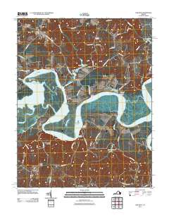
2011 Map of New Kent
USGS Topo · Published 2011About this map
The Pamunkey River snakes through this Tidewater landscape, defining the geography of eastern Virginia with its deep meanders and numerous historic riverfront sites. This 2011 edition documents a series of established waterfront points such as Riverview Landing, Cumberland Landing, and White Oak Landing, reflecting the area's long-standing reliance on river transport. The settlement pattern remains sparse and rural, centered on small communities like Lanesville, Lester Manor, and the county seat at New Kent.
Find a feature on this map
60 named features on this map. Tap any name to fly to it.
Don’t see what you’re looking for? This feature index may not catch every label — zoom into the map to look around manually.
Map Details
Editions of this 2011 New Kent Map
This is the sole edition of this map. No revisions or reprints were ever made.
Other maps of this area

1917 · Toano
USGS Topo · 1:62,500

1918 · Charles City
USGS Topo · 1:62,500

1918 · Toano
USGS Topo · 1:62,500

1919 · New Kent
USGS Topo · 1:62,500

1920 · King William
USGS Topo · 1:62,500

1943 · Richmond
USGS Topo · 1:250,000
1949 · Truhart
USGS Topo · 1:24,000
1949 · King William
USGS Topo · 1:24,000
1949 · King And Queen
USGS Topo · 1:24,000

1949 · Tunstall
USGS Topo · 1:24,000